Skip to content ↓

New way to predict how traffic will flow

Model provides a more accurate tool for city planning, emergency evacuations, tracking disease spread.
Press Inquiries

Press Contact:

Andrew Carleen
Phone: 617-253-1682
MIT News Office

Media Download

This diagram shows how researchers compute average traffic flows through a wider system of highways.
Download Image
Caption: This diagram shows how researchers compute average traffic flows through a wider system of highways.
Credits: Courtesy of the researchers
These diagrams depict the widely used “radiation” model used to analyze traffic flows (a) and the modified version (b) used by this research team, which adds a measure of the “cost” (in this case, time spent) of each possible route between two locations. That model is then used to compute average traffic flows through a wider system of highways, as depicted in the first image.
Download Image
Caption: These diagrams depict the widely used “radiation” model used to analyze traffic flows (a) and the modified version (b) used by this research team, which adds a measure of the “cost” (in this case, time spent) of each possible route between two locations. That model is then used to compute average traffic flows through a wider system of highways, as depicted in the first image.
Credits: Courtesy of the researchers
Actual data on traffic times through the U.S. highway system (a) and a closeup view of one region (b) are compared with comparable data obtained through the simulation system devised by the researchers (c and d), showing a good agreement between the two.
Download Image
Caption: Actual data on traffic times through the U.S. highway system (a) and a closeup view of one region (b) are compared with comparable data obtained through the simulation system devised by the researchers (c and d), showing a good agreement between the two.
Credits: Courtesy of the researchers

*Terms of Use:

Images for download on the MIT News office website are made available to non-commercial entities, press and the general public under a Creative Commons Attribution Non-Commercial No Derivatives license. You may not alter the images provided, other than to crop them to size. A credit line must be used when reproducing images; if one is not provided below, credit the images to "MIT."

Close
This diagram shows how researchers compute average traffic flows through a wider system of highways.
Caption:
This diagram shows how researchers compute average traffic flows through a wider system of highways.
Credits:
Courtesy of the researchers
These diagrams depict the widely used “radiation” model used to analyze traffic flows (a) and the modified version (b) used by this research team, which adds a measure of the “cost” (in this case, time spent) of each possible route between two locations. That model is then used to compute average traffic flows through a wider system of highways, as depicted in the first image.
Caption:
These diagrams depict the widely used “radiation” model used to analyze traffic flows (a) and the modified version (b) used by this research team, which adds a measure of the “cost” (in this case, time spent) of each possible route between two locations. That model is then used to compute average traffic flows through a wider system of highways, as depicted in the first image.
Credits:
Courtesy of the researchers
Actual data on traffic times through the U.S. highway system (a) and a closeup view of one region (b) are compared with comparable data obtained through the simulation system devised by the researchers (c and d), showing a good agreement between the two.
Caption:
Actual data on traffic times through the U.S. highway system (a) and a closeup view of one region (b) are compared with comparable data obtained through the simulation system devised by the researchers (c and d), showing a good agreement between the two.
Credits:
Courtesy of the researchers

A reliable way of predicting the flow of traffic could be a great convenience for commuters, as well as a significant energy-saver. During an emergency evacuation following a natural disaster, reliable predictions of the best routes could even be a lifesaver. Now a team of researchers from MIT, the University of Notre Dame, and elsewhere has devised what they say is an effective and relatively simple formula for making such predictions.

The findings are reported in a paper in the journal Nature Communications by researchers including Marta Gonzalez, an assistant professor of civil and environmental engineering and engineering systems at MIT and lead author Zoltan Toroczkai and Yihui Ren at Notre Dame.

The authors, all physicists by training, have been applying their knowledge of the computational modeling of complex systems to human-scale systems, such as traffic flows or the spread of disease. Their work has found patterns in these human systems similar to those seen in models of physical systems, the researchers say.

Traffic has traditionally been modeled using so-called gravitational models, but these have severe limitations, Gonzalez says. For one thing, such models have great difficulty adapting to changes in a network, such as those reflecting construction or emergencies — but the new model can handle such changes easily.

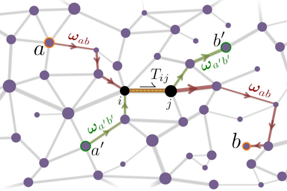
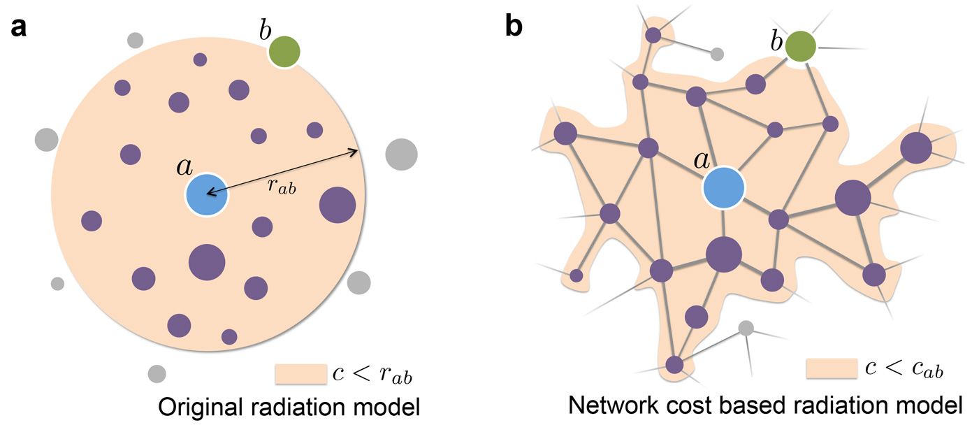
The system deals with the difficult-to-model human choices of destination sites, as well as the similarly difficult problem of choices of travel paths. In earlier work, Gonzalez and her colleagues developed a variation for the first ingredient of what is known as a “radiation model.” Such models are increasingly being used, but for traffic predictions, Toroczkai and Ren modified the model to include cost-based constraints for travel in the network, with travel time as the “cost” to be minimized.

In this application, certain locations — for example, daily destinations for many people, such as the MIT campus — are “absorbers,” pulling in vehicles from many directions; the locations where people live are “emitters.” In the new formula, the average number of travelers planning to go from point “A” to point “B” each day corresponds to voltage in an electrical system — essentially, the “pressure” between any two points — and the average number of travelers who actually follow a given road during that commute corresponds to the electrical current, or the actual amount of flow in such a system.

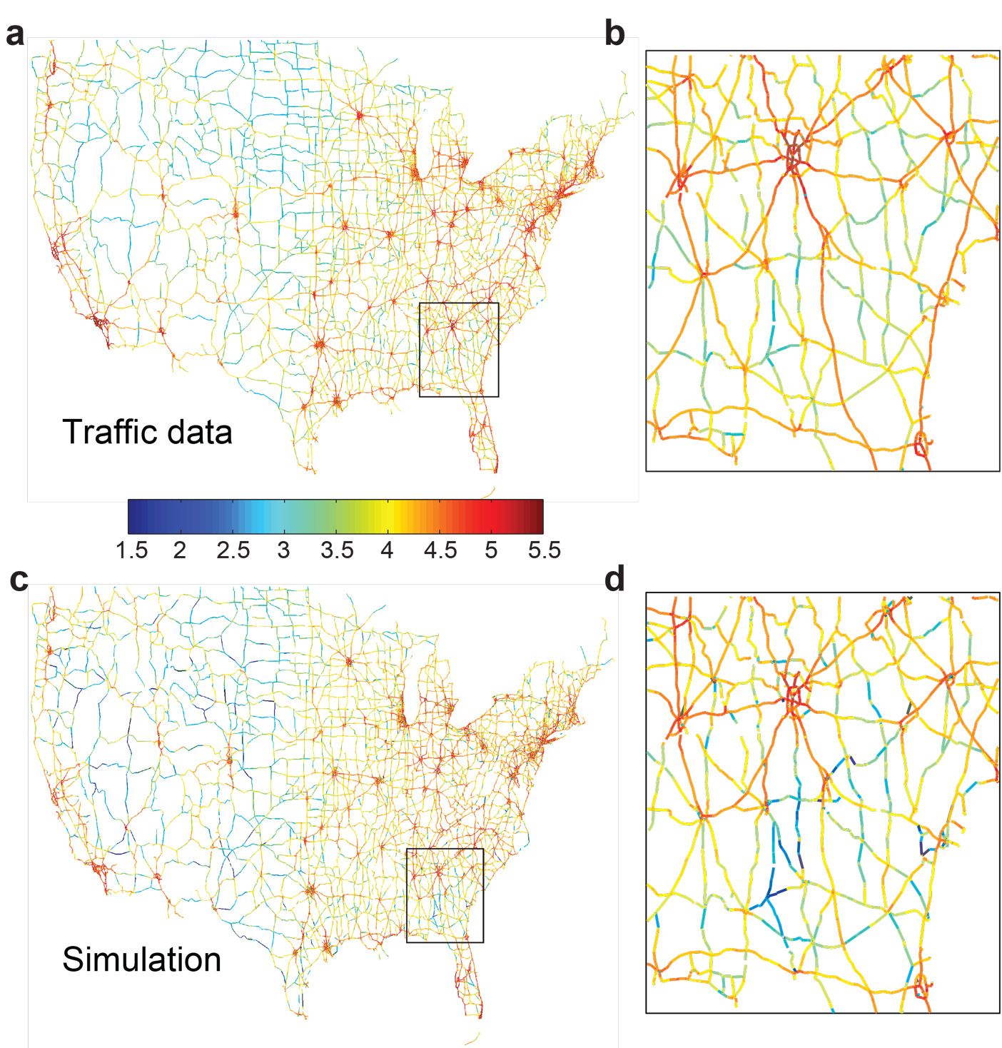
As input to the model, the researchers entered data on population distribution, from the U.S. census, as well as information on where people work and the basic structure of the highway network. Predictions made from the model have been tested, and found to correlate very well with actual traffic.

The radiation formula has enough flexibility that, having been tested and calibrated with U.S. traffic, it can be applied in areas where initial data is much more sparse. “It has been tested in South America and Africa,” Gonzalez says, with good results.

In disaster situations, the model might make it easier “to know how the system is going to be disrupted,” she says, and identifies critical points that may produce bottlenecks. The same basic modeling can be applied to any network flows that include human choices, including predicting patterns of the spread of disease.

“This work fills a gaping hole in our understanding of — and ability to predict — network flows,” says Stephen Eubank of the Network Dynamics and Simulation Science Lab at Virginia Tech, who was not involved in the study. “This work introduces a defensible approximation method that takes maximal advantage of available data and is well-calibrated to actual flows, yet can be applied to hypothetical circumstances. These features ensure that it will have a significant practical impact on transportation planning.”

The team also included Maria Ercsey-Ravasz at Babes-Bolyai University in Romania and Pu Wang at Central South University in China. The work was supported by the Defense Threat Reduction Agency, the Defense Advanced Research Projects Agency, and the National Science Foundation.

Press Mentions

Salon

Prof. Marta González writes for Salon about her research showing drivers typically do not choose the optimal route that minimizes travel time. She explains her findings can be used to “design incentive mechanisms to alleviate congestion on busier roads, or carpooling plans based on individuals’ preferred routes.”

Related Links

Related Topics

Related Articles

More MIT News